Coastal Systems and Landscapes Mind Map (A Level)
A level · Geography · Checked against AQA and Edexcel · Updated 31 October 2026
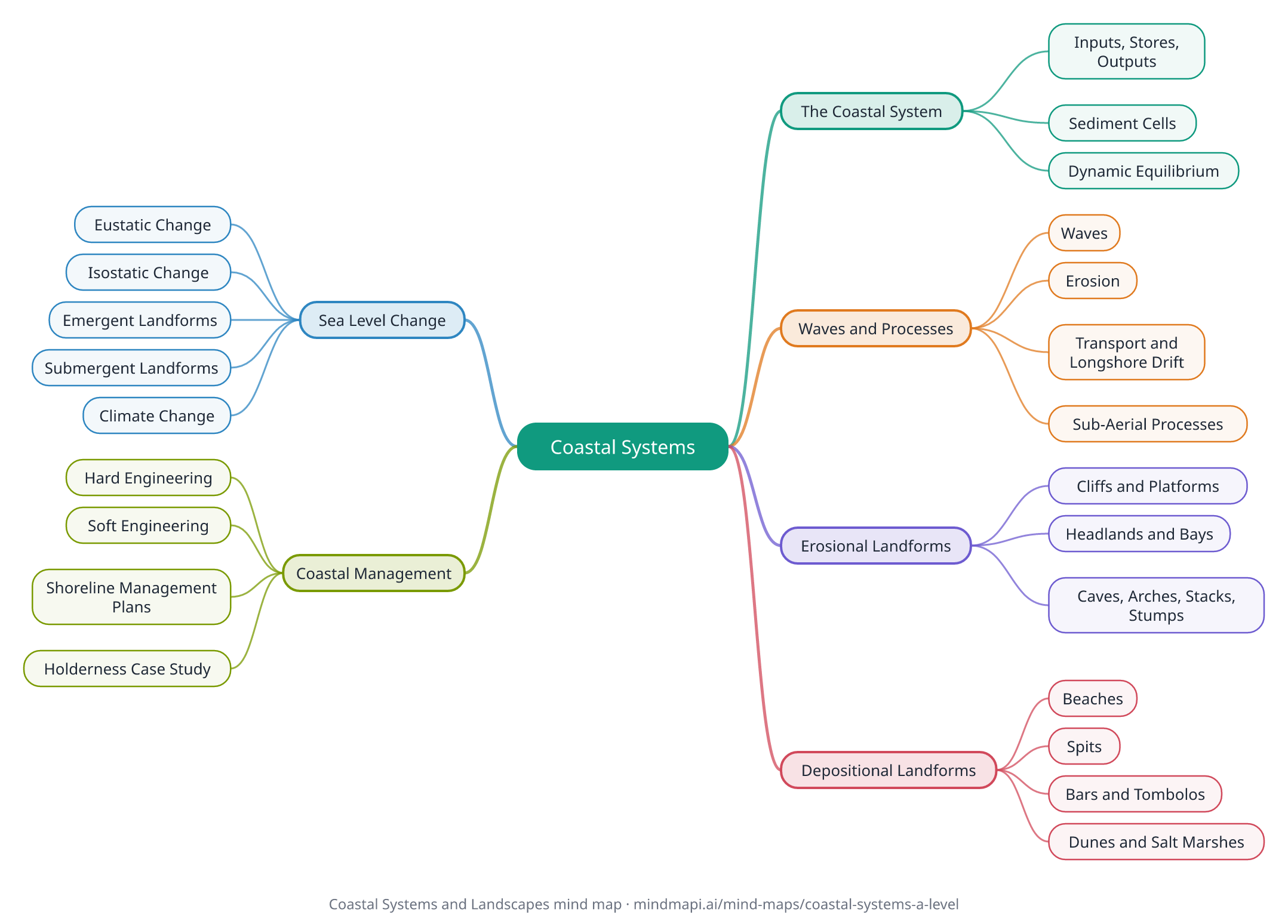
This coastal systems mind map puts the whole topic on one page: the coast as a system, waves and coastal processes, erosional and depositional landforms, sea level change, and how coasts are managed, with standard UK examples. Every branch is explained in the notes below the map.
It covers AQA's Coastal systems and landscapes and Edexcel's Coastal landscapes and change. Exam answers reward the systems language of inputs, flows and feedback, and named, located examples, so the map uses both.
Download this mind map
Print the map with all the notes as a PDF revision sheet, or save the map as an image. Free to use for revision and in class.
Coastal Systems and Landscapes mind map explained
The Coastal System
An open system, with energy and sediment moving in and out.
Inputs, Stores, Outputs
Inputs include energy from waves, wind and tides, and sediment from rivers, cliffs and the sea bed. Stores include beaches and spits. Outputs include sediment carried offshore.
Sediment Cells
Stretches of coast where sediment movement is largely self-contained. England and Wales are divided into eleven major cells.
Dynamic Equilibrium
When inputs and outputs balance, the landscape stays stable. A change triggers negative feedback, which tends to restore the balance.
Waves and Processes
Energy from waves shapes the coast.
Waves
Wave energy depends on wind speed, duration and fetch. Constructive waves (strong swash) build beaches; destructive waves (strong backwash) erode them.
Erosion
Hydraulic action, abrasion, attrition, solution and wave quarrying.
Transport and Longshore Drift
Sediment moves by traction, saltation, suspension and solution. Waves hitting the coast at an angle move it along the shore by longshore drift.
Sub-Aerial Processes
Weathering (mechanical, chemical and biological) and mass movement, such as rockfalls and rotational slumping, weaken and remove cliff material.
Erosional Landforms
Most common on high-energy, rocky coasts.
Cliffs and Platforms
Erosion at the cliff base forms a wave-cut notch; the cliff collapses and retreats, leaving a wave-cut platform.
Headlands and Bays
Form on discordant coasts, where bands of resistant and less resistant rock meet the sea.
Caves, Arches, Stacks, Stumps
Erosion exploits weaknesses in a headland, forming a cave, then an arch, then a stack and finally a stump. Old Harry Rocks and Durdle Door in Dorset are classic examples.
Depositional Landforms
Form where sediment is deposited, usually in low-energy areas.
Beaches
Stores of sand and shingle, shaped by constructive and destructive waves, with features such as berms and cusps.
Spits
Longshore drift carries sediment past a change in the coastline, building a ridge out to sea, often with a hooked end. Example: Spurn Head.
Bars and Tombolos
A bar joins two headlands, often trapping a lagoon, as at Slapton Ley. A tombolo joins an island to the mainland, as Chesil Beach does with Portland.
Dunes and Salt Marshes
Sand dunes develop through plant succession (a psammosere); salt marshes form in sheltered estuaries (a halosere).
Sea Level Change
Long-term changes in sea level shape the coast.
Eustatic Change
A global change in sea level, from changes in the volume of ice or the thermal expansion of seawater.
Isostatic Change
A local change in the level of the land. After the last ice age, Scotland is still rising while southern England sinks.
Emergent Landforms
Where land has risen relative to the sea: raised beaches and relict cliffs.
Submergent Landforms
Where the sea has risen relative to the land: rias (drowned river valleys) and fjords (drowned glacial valleys).
Climate Change
Rising sea levels and stormier weather increase flooding and erosion risk.
Coastal Management
Protecting people and property, balancing cost, effectiveness and environmental impact.
Hard Engineering
Sea walls, groynes, rock armour, gabions and revetments. Effective but expensive, and groynes can starve beaches further along the coast of sediment.
Soft Engineering
Beach nourishment, dune regeneration and managed realignment, which work with natural processes.
Shoreline Management Plans
Set a policy for each stretch of coast: hold the line, advance the line, managed realignment or no active intervention.
Holderness Case Study
One of Europe's fastest-eroding coastlines, losing around 2 metres a year on average. Groynes and rock armour at Mappleton protect the village but increase erosion to the south.
How to revise with this mind map
- Use systems language. Describe coasts in terms of inputs, stores, flows, outputs and feedback: examiners reward it.
- Learn landforms as sequences with labelled diagrams, such as the cave to arch to stack to stump sequence, or how a spit forms. Each stage needs a process.
- Know located examples. Name and locate a real place for each landform and each management approach, with specific details.
- For management questions, evaluate. Weigh cost, effectiveness, sustainability and the impact on other stretches of coast, and reach a judgement.
- Make it yours. Build your own coasts map in Mindmapi from your notes, and ask the AI about any landform or case study you are unsure of. The answer is saved into that branch's notes for next time.
Frequently asked questions
What is a coastal system?
The coast seen as an open system, with inputs of energy and sediment, stores such as beaches and spits, flows such as longshore drift, and outputs. Sediment cells divide the coast into largely self-contained systems.
How does a spit form?
Longshore drift carries sediment along the coast. Where the coastline changes direction, the sediment is deposited, building a ridge out to sea. Changing wind and wave directions can curve its end into a hook. Spurn Head is a well-known example.
What is the difference between eustatic and isostatic sea level change?
Eustatic change is a global change in sea level, caused by changes in ice volume or the thermal expansion of seawater. Isostatic change is a local change in the level of the land, such as land rising after the weight of ice sheets is removed.
What is the difference between hard and soft engineering?
Hard engineering builds structures such as sea walls and groynes to resist the sea. Soft engineering, such as beach nourishment and managed realignment, works with natural processes and is usually cheaper and more sustainable.
What are Shoreline Management Plans?
Plans that set a management policy for each stretch of coast in England and Wales: hold the line, advance the line, managed realignment, or no active intervention.
How do I make my own coastal systems mind map?
Put coasts in the centre and add branches for the coastal system, processes, erosional landforms, depositional landforms, sea level change and management, with a located example on each. To save time, paste your notes into Mindmapi and it will build a first draft of the map for you to edit.
Turn your own notes into a mind map
Upload your class notes, a PDF or a lecture recording and Mindmapi builds the map for you. Your first map is free.
Try It Free


